Flood Risk Assessment and Reduction
On Memorial Day weekend in 1981, a year after John Mackey, the founder of Whole Foods Market, opened his first store in Austin, Texas, a nearby creek flooded parts of the city, including the first Whole Foods Market. Obviously, this wasn’t the demise of the company, but the first store was destroyed. With the efforts of volunteers and patrons, it eventually reopened. Mackey went on to diversify his company which ended up becoming a huge success, and, of course, he purchased flood insurance.
Prudent business owners in flood prone areas are wise to take the necessary steps to mitigate flood risk as part of their long-term planning strategy.
Unlike Whole Foods Market, many businesses do not recover from such circumstances. In fact, the Federal Emergency Management Agency (FEMA) states that nationally, 40% of businesses do not reopen after a disaster. For those who do reopen, what can they do to protect them from flooding, including less severe, more frequent events?
Determining Flood Risk Exposure
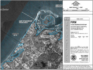
In order to mitigate flood risk, the first step is to determine the flood risk exposure of the property. According to FEMA, flood risk is defined in terms of expected probability and frequency, exposure, and consequences of flooding scenarios. The National Flood Insurance Program (NFIP) has conducted studies of risk prone areas and have published Flood Insurance Rate Maps (FIRMs). FIRMs provide flood insurance agents and design professionals with quantitative data which is referenced in insurance policies and the State Building Code. These maps show locations of potential flooding based on recurrence intervals or the probability of a flood hazard occurring over a certain time period. Most commonly, the FIRMs show the limit of the 1% annual chance of flooding, or the “one-hundred-year storm”.
Using these maps, design professionals can conduct risk assessments to evaluate the potential losses associated with buildings located in the flood zone. The most common accepted document used to determine flood risk is an “Elevation Certificate”. Prepared by Registered Design Professionals, Elevation Certificates are used to identify critical risk factors such as elevation of grades around the building, elevation of lowest floor, location of utilities, and foundation type. Elevation Certificates are also used by insurance underwriters to establish the cost of flood insurance and the cost/benefit of implementing risk management strategies. Other types of assessments that may be useful to a business include an evaluation of potential consequential damages from flooding (business closure timeframe, loss of property, loss of reputation, etc.) and an evaluation of the shoreline resiliency for floodways that may impact the building.
Once the risk exposure of a structure has been determined, civil engineering design professionals and insurance agents can assess ways to reduce risk. This typically includes:
- Reducing physical risk of flooding.
- Compensating for risk through insurance.
- Managing an acceptable level of residual risk.

Flood Insurance Rate Maps (FIRMs) show locations of potential flooding based on recurrence intervals or the probability of a flood hazard occurring over a certain time period.
Physical Risk Reduction
Factors evaluated for potential physical risk reduction include:
- Siting of the structure in reference to flood zones: Design professionals analyze the elevation and location of the existing structure. The elevation of the building in reference to its flood zone dictates the level of the predictable flood damage. Physical risk reduction of the siting may include relocating the building out of the flood zone or raising it to a higher elevation. For new construction, the State Building Code has statutory requirements for siting of a building in a flood zone so that the risk is minimized.
- Location of utilities and mechanical components critical to the function of the building: Often, some very expensive components of the building – the utilities – are kept in low elevation spaces such as the basement. Relocating utilities to areas above the flood elevation will reduce the risk of flooding to these components.
- Building foundation and framing system: Supplementing the existing foundation or replacing it in its entirety with a more suitable foundation for the flood zone will reduce the physical risk.
- Composition of building materials: Replacing the building materials below the flood elevation with flood damage resistant materials will reduce repetitive and expensive repair costs for lower intensity flood events.
- Waterproof enclosures or flood barriers: Waterproof enclosures or flood barriers are used to protect building floor areas located below the base flood elevation.
- Shoreline resiliency: Design professionals can assist in ways of reducing flood risk by increasing protection of the adjacent shoreline.
Risk Reduction through Insurance
Physical risk reduction such as raising a building to meet the flood elevation may be costly, however, business owners can supplement some of the remaining risk with insurance policies. Typically, risk reduction through insurance and physical risk reduction are proportional, meaning the cost of insurance is prorated when physical risk is reduced.

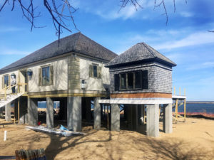
The floor elevation of this Chatham home was raised to exceed by 2′ the minimum elevation required by the Building Code using helical-supported concrete grade beam and vertical pier foundation with reinforced first floor support beams, thus reducing both physical and residual flood risk to the owner.
Managing an Acceptable Level of Residual Risk
Eliminating all risk is implausible. In order to do so, buildings would need to be designed to standards that would make them overly expensive with unlimited insurance policies. Therefore, it is important to determine an acceptable level of residual risk. For example, based on probability and statistics, there is a 26% chance of a one-hundred-year storm occurring over a 30-year time period. If this leaves an unacceptable level of residual risk, one may want to meet the design standards for the five-hundred-year storm, where there is a 7% chance of flooding over a 30-year time period.
Case Study: Reducing Physical and Residual Risk in Chatham
Our firm provided structural engineering design and construction contract administration to replace existing foundation underneath residential building located in a FEMA High Hazard Flood Velocity Zone in Chatham. The floor elevation was raised to exceed by 2′, the minimum elevation required by the Building Code, in order to provide additional protection from flooding. Our design specified helical-supported concrete grade beam and vertical pier foundation with reinforced first floor support beams, thus reducing both physical and residual flood risk.
To ensure the resiliency of your home or businesses located in coastal areas, it is important to consult with a knowledgeable team of design professionals and insurance agents so that the level of flood risk is assessed and risk reduction measures are evaluated.


